
Digital Highway Data Vehicle (DHDV) contains the heart and soul of WayLink's technologies. The vehicle, built on a heavy-duty truck chassis, such as Ford E-350, integrates various sub-systems in an all-encompassing framework as follows:
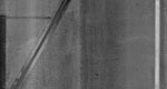
APSI-4096 conducts a full-lane width distress survey of pavements at speeds of up to 60 mph (100 Km/h) at 1-mm resolution, and process the data at real time. It uses the laser imaging system to rid of shadows and provide uniform and consistent high contrast pavement images during or or night.
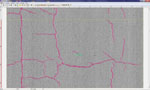
ADA is a product of many years of research and development. ADA is capable of producing crack maps to identify types, geometries, and directions of cracks at 60 MPH (100 Km/h). ADA was designed to conduct full cracking surveys at real-time along with the APSI-4096 with images and analysis results saved into location referenced database tables.
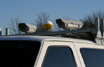
This sub-system captures imagery of roadway, pavements, signs, and other Right-of-Way features. Using multiple high-resolution, area-scan color cameras, PRIS is able to produce images of unprecedented quality. Camera options include baseline 1300-pixel color cameras, High-Definition (HD) 1080p color cameras, and Ultra HD color cameras.
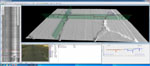
A user-focused application allowing for data review and editing in an office environment. This application is designed to display all the data sets collected during a DHDV collection procedure. More importantly, distress information can be easily edited and added into the pavement database tables through the use of the deluxe version of MHIS.
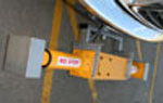
Laser Rut Measurement System (LRMS) is a transverse profiling system, capable of acquiring full 4 m (13ft 5in) width profiles of highway lanes at speeds up to 100 Km/h (60 mph) at the resolution of more than 1200 points.
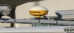
WayLink Systems Corp. installs an array of positioning systems in DHDV to represent the vehicles speed, bearing, location, and other general positioning data sets. This array consists of a heavy duty Distance Measuring Instrument (DMI); a self-contained, differential GPS receiver and antenna. A solid-state, multi-axis, inertial sensing Gyroscope, or a high-end Inertial Measurement Unit (IMU) are the user selectable options.
Dedicated, high-frequency, high-intensity lasers, for collecting longitudinal roughness data for use in calculations of International Roughness Index (IRI), Ride Number (RN), and Macrotexture (MT).